


Scituate Precinct 1, Plymouth County, Massachusetts
About
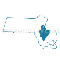
Outline

Summary
| Unique Area Identifier | 595193 |
| Name | Scituate Precinct 1 |
| County | Plymouth County |
| State | Massachusetts |
| Area (square miles) | 4.57 |
| Land Area (square miles) | 4.56 |
| Water Area (square miles) | 0.02 |
| % of Land Area | 99.66 |
| % of Water Area | 0.34 |
| Latitude of the Internal Point | 42.21102610 |
| Longtitude of the Internal Point | -70.79337900 |
Maps


Graphs
Select a template below for downloading or customizing gragh for Scituate Precinct 1, Plymouth County, Massachusetts


Neighbors
Neighoring Voting District (by Name) Neighboring Voting District on the Map
- Cohasset Precinct 1, Norfolk County, MA
- Cohasset Precinct 2, Norfolk County, MA
- Hingham Precinct 4, Plymouth County, MA
- Norwell Precinct 3, Plymouth County, MA
- Scituate Precinct 2, Plymouth County, MA
- Scituate Precinct 3, Plymouth County, MA
- Scituate Precinct 5, Plymouth County, MA
Top 10 Neighboring County Subdivision (by Population) Neighboring County Subdivision on the Map
- Hingham town, Plymouth County, MA (22,157)
- Scituate town, Plymouth County, MA (18,133)
- Norwell town, Plymouth County, MA (10,506)
- Cohasset town, Norfolk County, MA (7,542)
Top 10 Neighboring Place (by Population) Neighboring Place on the Map
Top 10 Neighboring Unified School District (by Population) Neighboring Unified School District on the Map
- Hingham School District, MA (22,157)
- Scituate School District, MA (18,133)
- Norwell School District, MA (10,506)
- Cohasset School District, MA (7,542)
Top 10 Neighboring State Legislative District Lower Chamber (by Population) Neighboring State Legislative District Lower Chamber on the Map
- Third Plymouth District, MA (42,782)
- Fifth Plymouth District, MA (41,874)
- Fourth Plymouth District, MA (40,475)
Top 10 Neighboring State Legislative District Upper Chamber (by Population) Neighboring State Legislative District Upper Chamber on the Map
Top 10 Neighboring 111th Congressional District (by Population) Neighboring 111th Congressional District on the Map
Top 10 Neighboring Census Tract (by Population) Neighboring Census Tract on the Map
- Census Tract 4231, Norfolk County, MA (7,542)
- Census Tract 5012.02, Plymouth County, MA (7,131)
- Census Tract 5052, Plymouth County, MA (6,674)
- Census Tract 5051.01, Plymouth County, MA (6,468)
- Census Tract 5041.01, Plymouth County, MA (5,370)
- Census Tract 5041.02, Plymouth County, MA (5,136)
- Census Tract 5051.02, Plymouth County, MA (4,991)